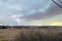
...A SEVERE THUNDERSTORM WARNING REMAINS IN EFFECT UNTIL 430 PM MDT
FOR SOUTHEASTERN CUSTER...NORTHWESTERN OGLALA LAKOTA...NORTHEASTERN
FALL RIVER AND SOUTH CENTRAL PENNINGTON COUNTIES...

At 346 PM MDT, severe thunderstorms were located along a line
extending from 7 miles east of Fairburn to 4 miles west of Red Shirt
Table Overlook to 5 miles north of Prairie Winds Casino, moving east
at 25 mph.

HAZARD...60 mph wind gusts and half dollar size hail.

SOURCE...Radar indicated.

IMPACT...Hail damage to vehicles is expected. Expect wind damage to
roofs, siding, and trees.

Locations impacted include...
Dry Wood Housing, Red Shirt, Intersection of Red Shirt and Cuny
Table Roads, Red Shirt Table Overlook and southwestern Badlands
National Park.

PRECAUTIONARY/PREPAREDNESS ACTIONS...

For your protection move to an interior room on the lowest floor of a
building.

&&


HAIL THREAT...RADAR INDICATED;
MAX HAIL SIZE...1.25 IN;
WIND THREAT...RADAR INDICATED;
MAX WIND GUST...60 MPH